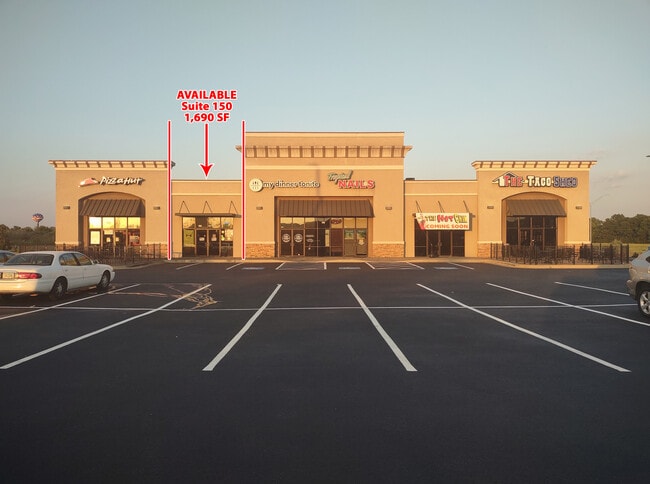
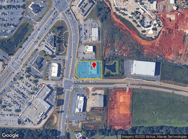
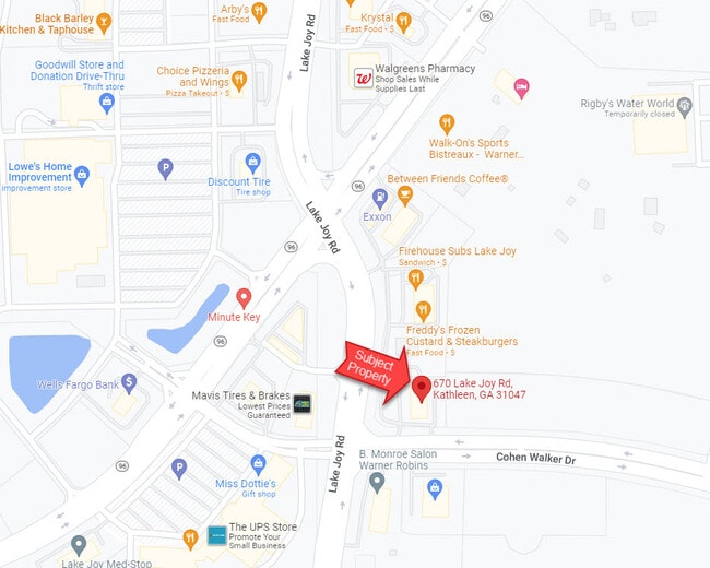
Property Record
670 Lake Joy Rd, Warner Robins, GA 31088
NEARBY LISTINGS FOR SALE OR LEASE
Property Detail
670 Lake Joy Rd
Warner Robins, GA
Hwy 96 Lake Joy Sf
0W1030046000
TRACT A 1.16 ACRES 133/10TH
Stripcommercialcenter
Houston
X
Georgia
13225C0150C
133
2024
1.16 AC
2024
Perry/Warner Robins
021119
Other Market Areas
8,255 SF
DEMOGRAPHICS near 670 Lake Joy Rd
1 Mile
3 Mile
5 Mile
2024 Total Population
3,628
39,683
85,463
2029 Population
3,934
43,185
93,614
Pop Growth 2024-2029
+ 8.43%
+ 8.82%
+ 9.54%
Average Age
37
37
37
2024 Total Households
1,298
14,237
32,476
HH Growth 2024-2029
+ 8.01%
+ 8.58%
+ 9.33%
Median Household Inc
$109,789
$102,809
$86,064
Avg Household Size
2.80
2.80
2.60
2024 Avg HH Vehicles
3.00
2.00
2.00
Median Home Value
$254,565
$198,182
$184,893
Median Year Built
2003
2002
1998
Nearby Places
Map Layers
Map Styles
 Street
 Aerial
- Restaurants
- Banks
- Shops
- Fitness
- Groceries
SALE & LEASE HISTORY
LISTING DATE
SALE/LEASE

Sep 25, 2016
For Lease
Jun 27, 2022
For Lease
Jan 24, 2018
For Sale
Feb 19, 2018
For Sale
Feb 01, 2017
For Sale
Dec 21, 2022
For Lease
Nearby Properties
Address
Land Use
TOTAL SIZE
Lot Size
Zoning
Address
Land Use
TOTAL SIZE
Lot Size
Zoning
80,000 SF
46.13 AC
R2
Address
Land Use
TOTAL SIZE
Lot Size
Zoning
15,006 SF
30.30 AC
R4
Address
Land Use
TOTAL SIZE
Lot Size
Zoning
5,400 SF
22.93 AC
R4
Address
Land Use
TOTAL SIZE
Lot Size
Zoning
5,648 SF
49.72 AC
R4
Address
Land Use
TOTAL SIZE
Lot Size
Zoning
9,828 SF
18.63 AC
R4
Address
Land Use
TOTAL SIZE
Lot Size
Zoning
5,440 SF
36.50 AC
R4
Address
Land Use
TOTAL SIZE
Lot Size
Zoning
273,000 SF
63.42 AC
C2
Address
Land Use
TOTAL SIZE
Lot Size
Zoning
219,205 SF
26.17 AC
R2
Address
Land Use
TOTAL SIZE
Lot Size
Zoning
54,900 SF
19.60 AC
C-2, WR
Address
Land Use
TOTAL SIZE
Lot Size
Zoning
112,824 SF
13.07 AC
C2
Address
Land Use
TOTAL SIZE
Lot Size
Zoning
112,824 SF
Address
Land Use
TOTAL SIZE
Lot Size
Zoning
112,824 SF
Address
Land Use
TOTAL SIZE
Lot Size
Zoning
28,668 SF
17.38 AC
R4 C2
Address
Land Use
TOTAL SIZE
Lot Size
Zoning
158,300 SF
43.81 AC
GU
Address
Land Use
TOTAL SIZE
Lot Size
Zoning
67,732 SF
25 AC
R4
Address
Land Use
TOTAL SIZE
Lot Size
Zoning
76,751 SF
26.32 AC
R1
Address
Land Use
TOTAL SIZE
Lot Size
Zoning
122,858 SF
8.64 AC
C2
Address
Land Use
TOTAL SIZE
Lot Size
Zoning
100,500 SF
19.64 AC
R2
Address
Land Use
TOTAL SIZE
Lot Size
Zoning
78,956 SF
9.05 AC
C2
Address
Land Use
TOTAL SIZE
Lot Size
Zoning
100,500 SF
19.74 AC
R2
Address
Land Use
TOTAL SIZE
Lot Size
Zoning
38,112 SF
8.84 AC
R4
Address
Land Use
TOTAL SIZE
Lot Size
Zoning
6,624 SF
8.08 AC
R4
Address
Land Use
TOTAL SIZE
Lot Size
Zoning
6,574 SF
10.14 AC
R4
Address
Land Use
TOTAL SIZE
Lot Size
Zoning
85,580 SF
33.60 AC
R2
Address
Land Use
TOTAL SIZE
Lot Size
Zoning
4,592 SF
10.20 AC
R4
Address
Land Use
TOTAL SIZE
Lot Size
Zoning
138,518 SF
14.72 AC
C2
Address
Land Use
TOTAL SIZE
Lot Size
Zoning
79,638 SF
6.65 AC
C2
Address
Land Use
TOTAL SIZE
Lot Size
Zoning
68,601 SF
7.50 AC
C2
Address
Land Use
TOTAL SIZE
Lot Size
Zoning
38,593 SF
6.49 AC
RAG
Address
Land Use
TOTAL SIZE
Lot Size
Zoning
30,867 SF
0.23 AC
C2
The World's #1 Commercial Real Estate Marketplace
Connect with us
© 2025 CoStar Group
The information above has been obtained from sources believed reliable. While we do not doubt its accuracy we have not verified it and make no guarantee, warranty or representation about it. It is your responsibility to independently confirm its accuracy and completeness. Any projections, opinions, assumptions, or estimates used are for example only and do not represent the current or future performance of the property. The value of this transaction to you depends on tax and other factors which should be evaluated by your tax, financial, and legal advisors. You and your advisors should conduct a careful, independent investigation of the property to determine to your satisfaction the suitability of the property for your needs.